Friday, August 26, 2011

Crossing Lake Michigan to Chicago


We got lucky. After a week of high winds on Lake Michigan where we have been stuck in the same town for too long, we hit a beautiful day to cross. Just gorgeous. Our intention was to make a short jump down the coast to St. Joe, Michigan, so we did not get up early. But the weather report was perfect, and it was going to get horrible again, after today. So at 9:30 this morning we left South Haven, MI, and headed the 90 miles across the lake to Chicago.

As you can see it was smooth. We had a hitchhiker join us. We noticed several small birds, smaller than a sparrow, but orange, landing on the back of the boat. Carla Smith would know what they were. All I know is that they were very tired out in the middle of the lake as they were headed south. So we had birds fly into the boat, and basically ride with us the rest of the way into Chicago. Glad to help.

Shelley made a picnic lunch and we enjoyed it on the front deck while the autopilot steered us on our course. We cleaned the boat, and I took the opportunity to polish half of the chrome. We have a lot of chrome, so I only got half of it done. 8.5 hours of cruising at 10 mph , burning 24 gallons of fuel, and we had a spectacular approach into Chicago. It was a fabulous day...one that will stand out in a trip of spectacular days, and one that Shelley and I will remember forever.

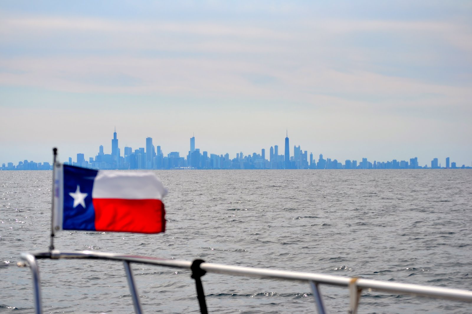
Shelley saw it first. We were still 46 miles out, and you could just make out the Sears Tower and the Hancock Tower over the horizon. Slowly the entire skyline filled in, and an impressive skyline it is. We are staying at the Burnham Park Harbor in the shadow of Soldier Stadium. The Adler Planetarium, the Shedd Aquarium, and the Natural History Museum are all within a block of the yacht harbor. So we will have lots to entertain ourselves over the next 4 days. The Bears are not in town, but hopefully we can see a Cubs game.

My roommate from law school, Lauren Hogan, lives here in Chicago. We are going to have dinner with he and his wife Joyce, while we are in town. This will be a great transition from spending the last month and a half in Canada and the pristine waters of northern Michigan, into the inland river system of the US. The Illinois, Mississippi, Ohio, Cumberland, Tennessee, and Black Warrior will take us from Chicago to Mobile Alabama. Wow.


Thursday, August 25, 2011

Sand Dunes and Big Waves


Well the theme for Lake Michigan is Big Waves, Beautiful Sand Dunes, and really nice villages along the shoreline. We just spent 4 nights in Grand Haven, Michigan, which was 2-3 nights longer than we wanted (are you surprised by that?). The wind was howling out on the Lake, creating waves of 8+ ft. We had no desire or business to go out in that kind of stuff, so we sat. Yesterday, we rented a car and drove to several of the places that we had not been able to take the boat to as we came down the lake.

Several of these photos are Silver Lake which resides along the shores of Lake Michigan, separated by these 200-300 ft. sand dunes. Silver Lake continues to get smaller and shallower each year as the consistent wind off Lake Michigan moves the sand into the little lake, and fills it up. This is especially true in the winter. The lake freezes over and gets covered by a ft. or more of sand over the course of the winter. Springtime comes and all the sand sinks to the bottom filling the lake. Several people have built houses close to the dunes, which of course were soon covered with sand up to the rafters, just like snow. Their choice was to abandon the home, or move it. Several haved moved them. We toured the dunes in this bright red Ford 250 custom made to handle the sand.

I have to give these Michigan'ers credit....they love their summers. It is cold up here at night, and the days are nice, but not hot by any standard. Maybe it is in the mid 70's. I know my family and friends are suffering through a record setting summer of 70+ days of over 100 degrees, but up here it is cool at best. Yet these folks are in their shorts and T-shirts and swimming in Lake Michigan like it was the Caribbean. Every town celebrates summer along the lake, with band shells, live music, water shows, farmer's markets, sailboat races, and half the population on the sandy beaches of Lake Michigan. It is cold, but you would never know it with these folks dressed like it was a 100 degrees. Oh well, it is what you are used to, and it is a short summer, so they live it to the max.

Today, after sitting for 4 days, we watched the weather then decided to head out and down the Lake. The wind had moderated to 15 kts. but the waves were still in the 6-8 ft. range. Every one else stayed in, but we thought we could make hay with these waves, especially with a following wind. Rock Chalk does well going downwind, so we made a 46 mile trip in a little over 2.5 hours. I had the boat up on plain, which is a normal cruise of 16 mph. But we could get her to surf down some of these 8 footers, and easily get to over 22 mph. It was fun. Shelley went up to the bow, and had a wild ride. I wish Max and Leo, could have been here for this part of the ride. At times, there was 8 to 10 feet of the bow out of the water as we crested these waves. Surfing Lake Michigan. Cool.

We are now in South Haven Michigan, and ready to cross the lake to Chicago. We will watch the weather and find a good window, with winds less than 10 and waves of less than 2 ft. Right. We plan on spending several days in Chicago and see my old friend from law school, Lauren Hogan and his wife Joyce. So the next blog will probably show the skyline of Chicago from Lake Michigan. I can't wait. Marc

Saturday, August 20, 2011

Sand Dunes of Lake Michigan


Voted as the most beautiful spot in America, these sand dunes on the eastern shore of Lake Michigan are pretty. So I asked Shelley, why sand dunes? Naturally as we are cruising down the coastline, she googles the geology of Lake Michigan, and voila its the glaciers. 16 million years ago, the glaciers dug out the Great Lakes, and covered this entire area with over a thousand feet of ice. As it melted it left the Glacial Drift, ie sand across the lakes and the land of Michigan. The lakes then pushed the sand up into sand dunes over millions of years, and formed these beautiful bluffs.

Navigation here is pretty easy. We take the boat about a mile offshore, and head south. We have been in 600 ft. depths of the lake, just a mile offshore. The biggest issue is the weather forecast. We look at three different sources of weather for the lake, and natually they each have a different forecast. I do not want to go out into Lake Michigan in seas greater than 3 ft. and winds in excess of 15-20. The prevailing wind is from the west, so when we are going south, that makes a beam sea. Not much fun with a 3 ft sea off the starboard side. So if that is the forecast, we stay inshore.

Fortunately Michigan has a harbor of refuge or a protected anchorage about every 25 miles as you go down the coast. Many of these are pretty villages that are set back from the Lake, inside protected seawalls. We have stayed at quite a few of these villages. Each has numerous marinas and cater to the boating community, which is quite large in the summertime. These last three nights we have stayed in Pentwater, MI. These folks make their living off the high season of boating, and they are good at it. Lots of small shops, restaurants, bars, and all the things that tourists need and want. Beautiful little town.

Tomorrow we head 60 miles further down the coast to Grand Haven. This is a small village where the Grand River runs into the Lake, just down from Grand Rapids, Michigan. We will be in South Haven by the end of the week, preparing to cross the bottom of Lake Michigan to Chicago. That will be another major landfall for us as we reach the end of the Great Lakes, and head into the inland river systems of the US. I am ready for the next major adventure of this trip....the rivers. Marc


Sunday, August 14, 2011

Lake Michigan


The ferry at Mackinac Island with its jet tail and wall clouds coming at us.

Let's state the obvious. Lake Michigan is big. After 500 miles of rivers, canals, locks, and tiny passages between granite, Rock Chalk is now entering its next major segment of the Loop. When you are traveling at the speed of a golf cart, you can think about stuff. OK, here are two things that I think about.

First, our furthest east spot was New York City. The Hudson travels slightly northwest from New York, and then you turn west into the Erie Canal. From there we traveled west and north for 500 miles. At noon today we turned South for the Gulf of Mexico. After departing Mackinaw City, Michigan and passing under the impressive bridge we headed west out into Lake Michigan. At Green marker #3 near White Shoal, you can turn south. That is the direction we will going from now until Christmas. Whew. Long way to Marathon. South we go.

Next, for those of you who do not know me, I have this uncanny ability to tell you where commercial jets are headed. My friends Joe Thompson and Roger Smith will attest as to how accurate I am when I see them crossing the sky leaving their contrails. So here is the latest, that naturally I think is really cool.

Over the North Channel/Georgian Bay of Lake Huron on a clear afternoon you are underneath the Big X. What is that you ask? Well, here goes. The first part of the X is made by jets flying from Europe. When you fly from any of the major gateway cities in Europe to Chicago or Dallas, you make this gentle arch across the North Atlantic, pass just south of Greenland and then across Canada. I have seen the Georgian Bay and the North Channel many times on our trips home from Europe. That is the first one.

But the really cool other part of the X are the flights coming from Asia to New York, Newark, or Wash. Dulles. Those flights are all scheduled to arrive in the mid afternoon just like the flights from Europe. But the flights from Asia fly close to Alaska and curve down across western Canada heading southeast to the East Coast. These flights cross over Georgian Bay at the same time as those from Europe heading southwest, and complete the Big X.

I know, Roger doesn't believe me, but its true. Really. You travel for 5 months at the speed of a golf cart and you think of stuff.......... Marc

Friday, August 12, 2011

Red Sky at Morning--Watch Out


I am sure you have heard the ole mariner saying..."Red sky at night Sailors delight, Red Sky at morning, Sailors take warning". Well, this was the sky as we left our last anchorage in Canada, Meldrum Bay Ontario. I checked the forecast on the VHF radio and it was OK until noon, but big storms were on the way. So we left at dawn and scooted west 40 miles to Drummond Island, Michigan where we re-entered the US. By noon it was blowing, and at 2:00 one of those large scary black wall clouds covered the horizon as it rushed toward us. It felt good to be well tied into the marina.

The rain and lightning was not as bad, but then the wind blew. And blew and blew. For 36 hours it felt like western Kansas in the spring. 30 mph winds, with gusts over 40. So we just hang at the marina and let it blow over. Boating requires patience, not one of my strong suits. So I cleaned everything I could, serviced the engines, had a mechanic change out one of the seals on the starboard drive shaft, and got the boat all ready for our next big segment of this journey....Lake Michigan.

Most people reading this blog are from Texas and Kansas. Don't know about you, but I really had not spent any time in Michigan. If you look at the very northern tip of the main part of the state, there is a bridge. That is the Mackinaw Straits bridge (I-75) that connects the lower main part of Michigan to the Upper Pennisula (UP). The bridge looks much like the Golden Gate. Its big. Mackinac Island sits two miles to the east of this bridge and is in Lake Huron. West of the bridge starts Lake Michigan. It is the border between the two great lakes. Mackinac Island is like Branson on the Great Lakes. Lots of tourists, ice cream and fudge shops, and restaurants focused on the tourists. It is pretty though.

I think of dumb stuff as I travel through these waters. Such as, who drew these state and national lines? Why did Michigan get the UP? Its this big long piece of land between Lake Michigan and Lake Superior that runs east and west. Why wasn't that part of Wisconsin. Those Wisconsin guys were poor negotiators I think. Who put the US-Canada border around Drummond Island (US) and Cockburn Island (Canada).
From the water they look identical and seem like nice neighbors. Who sat around the table with a big map and their pencils......

Oh well, the stock market is down, its a record setting hot summer, there are about 10 people running for President, and the world goes on. But I really would like to know who were those guys? Marc

Sunday, August 7, 2011

Hiking in Canada. Bears you say?


We are back in the US, and within reach of an internet connection. Yea!!! It has been over a week since we had any connection, so my blog is far behind. The above photos are some of the best anchorages we found in the Georgian Bay and the North Channel, all are part of Lake Huron. We anchored Rock Chalk and went ashore looking for bears. Really we were looking for fossils on Fossil Beach, but reportedly the local Bears like tourists looking for fossils. Oh Yogi, where are you?

It has been cool, and most days have been sunny. Just beautiful weather to cruise these islands and small bays. Leo and Max, be ready, because Mema found some really cool rocks on Fossil Beach, and they have cool fossils on the backside of the rocks. Mema has enough for Stella, Rylee, Luke, and the new baby coming this November in Lawrence. Rock Chalk is full of rocks, if we can just figure out how to get them home.

We arrived at Little Currnet Ontario which is the last major town in the North Channel. From there the Channel opens up. We had a beautiful weather window, with a storm coming the next day, so we turned the boat loose and headed west. We reached the furthest northern spot that we will come on the Loop at 46 degrees, 15 min. north....half way to the north pole from the equator. That tells me that this ole earth of ours is a big place, cause I feel like we have come a long ways, and really have only come from around 20 degrees north in the Florida Keys to 46 degrees north in Canada. Not even close to half of the distance from the equator to the north pole.

We re-entered the US at Drummond Island, Michigan and cleared customs at the marina there. Pretty easy process. Then we hunkered down as a major storm came across the great lakes. My brother tells me it was cool in Kansas, and LeRoy Holt in Oklahoma City had a big storm that did some damage. All of this was part of the same system that swept over us with Thunderstorms and high winds, giving us a preview of the fall storms we should encounter on Lake Michigan as we get closer to September. Good time to stay tied into a marina, and work on the boat. Shelley did not have internet, so she helped with the boat, and did a lot of reading. (Kindles work just fine.)

We spent a little over 3 weeks in Canada, and I am missing it already. It really was the highlight of the Loop so far. Just beautiful, and I hope I can see it in my boat again some day. The Canadians are great folks and very friendly. They too love their natural wonders and they get out in this short season to enjoy it to the max. I love it when its 62 and drizziling, and these guys are out in shorts and no shirt doing anything and everythin outdoors. I guess you would too if it was 20 below most of your winter.

Tonight we are in Mackinaw City Michigan. We are taking the ferry over to Mackinac Island (pronounced the same way, just spelled with a c) tomorrow to see what all the hubub is about with that island. We toured around the island in Rock Chalk as we came by it today, and could see the beautiful hotel and all the other tourist "stuff" there, but it should be fun to tour it.

The water is deep and clear so Lake Michigan is going to be another great place to explore. Marc

Friday, August 5, 2011

Shelley is 60!


This is what she wanted to do on her 60th. She wanted to be as far away as you can get to celebrate it quietly, and we were. We anchored last night in Mill Lake which is part of Collins Inlet from Georgian Bay. Latitude is 45.9 north and 81.1 west longitude. We are at the top of Georgian Bay and entered the North Channel today. This is the furthest north we will go, which is a long way north from anywhere, let alone Marathon in the Florida Keys.

They call Georgian Bay, the Lake of 30,000 Islands. You can see some of them in these photos. I have said this before, but this is the most challenging place to navigate. You have to watch every moment as the channels are narrow, and if you wonder off there is a lurking piece of granite with your name on it. But it is so very beautiful. We have had wonderful Canadian summer weather. Cool nights and very nice days. Perfect for swimming.

We need to hang out here in Canada for many more weeks before we start south. I really do not want to drive this boat into the heat that all are enjoying. Plus the Missouri is still flooding, which will make the 120 miles on the Mississippi below St. Louis (where the Missouri flows into the Mississippi) a real adventure full of fast water and big debris. So there is more adventure ahead.

I would come back here. It truly is a wonderful place to cruise, one of the best areas in the world. 3500 miles from Florida and $2000 of fuel is the pricetag. But it may be worth another trip via Lake Champlain and Quebec. Plus I just have to learn how to fish. Here we are in one of the best fishing spots in world and I have not wet a lure. That is not good. Maybe tomorrow. I am trying to hire a fishing guide, then convince Shelley she should go. Easier to hire the guide. Wait until you see the photo of me holding the big one. Marc


Monday, August 1, 2011

Another Post since we have Internet


I couldn't resist. We actually have internet at this marina so I had to catch up with my blog. This is such a beautiful place, that it is hard to pick the photos. We are averaging 75 new photos a day.

I had a generator issue last night when we were on the hook, so I came into this boat yard today for service. Nice place if you like boat yards. Not a fancy place by any means, but it was free. We just had to pay for 3 hours of labor while we figured out and fixed the generator. I say we, because I am trying to learn as much as possible about taking these things apart and putting them back together. I am getting better. Eh?

Tomorrow is a long day. 50 miles where we wind through the rocks some more, then outside into Georgian Bay for 20 miles. All of that is to avoid a really nasty narrow rocky part of the channel full of switchbacks and many areas to make a mistake. So I am going out to avoid all that. Then we come back in and head to Bing, Ontario. Cheapest fuel in Georgian Bay. I need 100 gallons. Tomorrow is forecast for light winds and a high of 80. It will be 62 tonight. No A/C needed here. Marc

Eh!!


You have to end every sentence with Eh! You also have to learn that the end of every sentence ends in an uptick in your voice. Very pretty language these Canadians speak, eh? Out sounds like oat. Now I know why my brother in law, Mark Rolland, is such a friendly guy. He must have some Canadaian in him, yes?

OK, the weather has been great, and the scenery unbeatable. Scary but unbeatable. This Canadian Shield thing is scary sometimes. They make the channels for the Canadian boats which have an 8 ft. beam. Not so much for a 19' beam like Rock Chalk. Some of these photos attached show you how small the channel is between the rocks. Eh!

Then you have to worry about the float planes. These guys take off in the main channel, so not only am I worrying about the rocks, and the other boats in my way, then a plane takes off right in front of us. You know?

We spent the last two days on the hook in a small bay called Shotgun. It gets its name because the entrance is about 25 ft wide. We barely fit in, but then it opens up. We sunk our anchor in a grassy bottom of 12 ft., right in the middle of this 100 ft wide bay, and backed up to the granite shore. I put out about 45' of chain and called it good, you know? It was very peaceful with the loons calling in the morning. There were 12 other boats sharing parts of Shotgun, and most used the Mediterranean method of anchoring in the middle and backing up to shore. But they tied to a tree or rock on shore. That cost you $10, eh! So Rock Chalk swung on its chain. Thats free you know? I slept like a baby. No worries.

We are working our way through this rock generally northward. Look at your map. Georgian Bay is what they call the sixth Great Lake. It is really part of Lake Huron, but its the rocky crumbly part that the glaciers left as they departed. They wanted to make a mess and they did, you know? Luckily there have been good folks before me, eh, and they marked the route. It is not straight, you know, but if you pay attention, and follow it exactly, you will be fine, eh.

So here is what the Canadians tell me, you know? There are two types of water in Georgian Bay, soft water and hard water, eh! There are also two kinds of boats and boaters in Georgian Bay, those that have hit a rock, and those that are about to, eh!

At least they can balance their national check book here and keep their Triple A rating from Moody's. You know. More than we can say about us Americans, eh?